GOLD PROSPECTING
GOLD PLACER DEPOSITS
In order to prospect for a mineral, you first have to define what you are looking for. For gold it consist of two things; gold lode ore and gold placer deposits. The gold lode ore consist of gold that is found in mines and runs in veins in the earth. This gold is expensive and dangerous to mine. The other type of gold found is the placer gold deposits. This gold is what these maps are intended to help you find.
What is a gold placer deposit?
Over the course of many years, heavy rains have eroded the mountains containing the gold strata or gold lode ore. As the mountains turned into hills through the erosion process, the gold lode ore was eroded and washed down from the hills and into runoff streams and creeks. The gold washed into these streams and creeks is considered placer gold deposits. Gold will be pushed down the creeks by the force of water and will eventually settle down to bedrock. However, during especially heavy rainfall events and major floods, the gold may be pushed even further down the stream. The gold will also settle out at spots in the creeks and stream where the stream water velocity slows significantly, thereby dropping the gold to the bottom of the stream, such as river bends, sand bars and deep holes in the stream bottom or where the stream suddenly widens out. Bedrock that has depressions, may hold rich pockets of gold as well as bedrock that is fissured. Well rounded placer gold is a sign that the gold has traveled far from the mother lode, while gold that is angular or nuggets or grains that contain quartz or other brittle minerals may be close to their source of gold from the hills.
Where do I look to find gold placer deposits?
First you need a good gold map. Mineral deposits have been well documented by the United States Geological Service,(USGS), in their Mineral Resource Data System (MRDS) files. These gold maps have the gold mines, placers, and claims plotted on USGS quad sheets with the latitude and longitude record numbers. The quad sheets are used in a GPS instruments to locate the gold site in the field. The maps will show you were the gold has been found and the GPS record number will let you find these points in the field. The GPS instrument inputs the USGS quad sheet, so you will find the site on your hand held GPS.
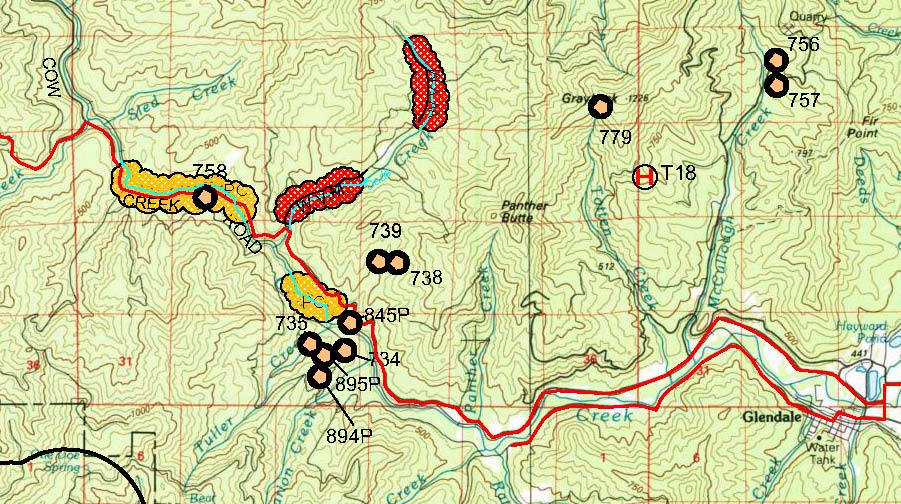
The example shown below is for a part of the USGS quad sheet of Canyonville, Oregon detail gold map which is part of the Medford, Oregon Gold Map. The gold sites are shown with the record numbers listed beside them. Each record number represent an actual placer deposit or mine that has produced gold. If a stream is at this site, there may be placer gold located here.
From the map below, if you were to gold pan at gold sites 845P, in the Cow Creek, adjacent to Cow Creek Road, in the vicinity of the town of Glendale, you may find some placer gold. According to the USGS, placer gold has been found in these claims at one time. However, records go back to the 1880's. The gold map also defines the characteristics of the land and topography. The elevation of the hills are around 500 meters (1500 feet) above sea level. The contours show you the elevation changes that you would encounter if you hiked to a gold site, say #738. You would have a climb of about 150 meters ( 150 feet ) for about a 2 mile hike from the paved road. ( 1 inch = about 1.6 miles) The contour intervals are 50 meters. Of course the gold trek may take a long time if you have to make your own trail and be careful not to get lost in the wilderness. There is a trail located in the vicinity of gold site 779 - hiking trail T18 by the Totten Creek. The GPS location instrument is ideal for this sort of thing. Input your starting coordinates and then the destination coordinates. You should be able to get pretty close to the gold site.
The record number latitude and longitude coordinates are documented by the USGS, however, they have not been field verified. They rely solely on the information provided by the person, corporation or state reporting that gold has been mined from the gold site. In fact, according to 2014 BLM records, there are active prospectors gold club claims along Cow Creek and Dads creek, in the vicinity of gold record number 758. (Shown in the yellow and red clouded area.) Gold panning in the streams and creeks can be interesting and challenging, and if you make a gold find very exciting.